Aircity

The mobility and spatial operations platform for Hong Kong

Modular software for transport operators, parking managers, government departments, and enterprise teams.

Built from real mobility and parking operations in Hong Kong.

509+ carparks under live tracking17,000+ metered parking spacesReal-time Hong Kong GTFS feeds

Product Modules

Six modules that cover fleet dispatch, parking, telematics, vision, spatial data, and local intelligence.

StationsOS

Dispatch, booking, and parking vacancy orchestration for on-demand mobility services.

  • 509+ live parking vacancy feeds
  • Booking and payment workflow control
  • WhatsApp + push notifications

FleetOS

Fleet management portal with telematics integration, hardware provisioning, vehicle lifecycle, and operational workflows.

  • Telematics hardware onboarding
  • Vehicle lifecycle and compliance tracking
  • Driver and fleet billing workflows

DataPipeOS

Real-time data pipeline for device telemetry, MQTT ingestion, and operational event streaming across fleets and sites.

  • MQTT broker with device provisioning
  • Real-time telemetry ingestion and routing
  • Event stream processing and alerting

AI Vision

Computer vision pipeline for site monitoring, occupancy verification, and event-based alerting.

  • YOLOv8 real-time detection
  • Multi-camera RTSP operations
  • Event alert workflow

Spatial Intelligence

Digital twin API, indoor mapping, and pedestrian network data for planning and operations.

  • 701 venues mapped
  • 467K+ route segments
  • GTFS transit integration

MediaOS

Agentic data collation across media categories — structured, organized, and maintained for institution-grade consumption with secure AI tooling.

  • Automated SQL schema design and maintenance
  • Multi-source media ingestion and structuring
  • Secure AI agents for data governance
Google Maps Platform Innovators Badge
Recognition

Google Maps Platform Innovators

Aircity is a recognised member of the Google Maps Platform Innovators program — awarded to organisations that demonstrate advanced implementation of Google Maps APIs in production systems.

Earned Dec 2024

Solutions by Sector

Defined delivery scope for public institutions and enterprise operators.

For Mobility Operators

For Mobility Operators

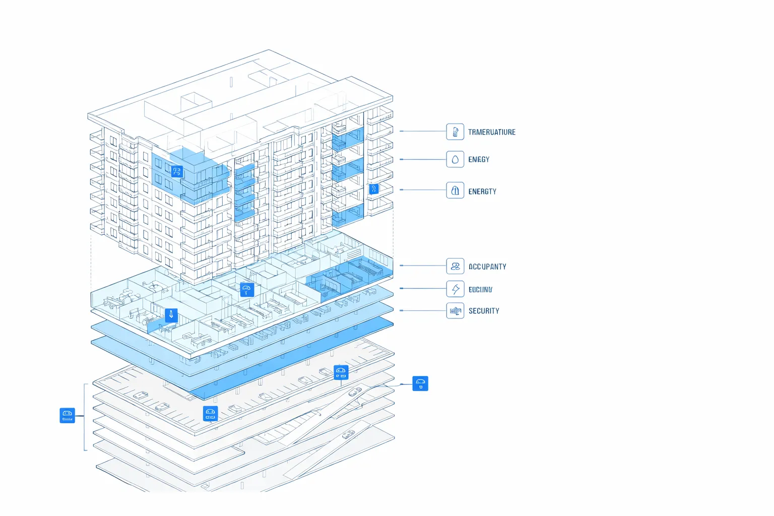
Fleet operations, dispatch governance, telematics, and transaction control in one stack.

StationsOSDataPipeOSFleetOS
  • Real-time fleet status and exception monitoring
  • Dispatch decisions with carpark vacancy context
  • Integrated booking, payment, and auditable records
View operating workflow
For Carpark Operators

For Carpark Operators

Carpark occupancy operations, access flow, navigation, and revenue control.

StationsOSSpatial IntelligenceAI Vision
  • Live vacancy data across 509+ carparks
  • Indoor wayfinding linked to service operations
  • Computer vision occupancy verification workflow
View operational data
For Real Estate Managers

For Real Estate Managers

Building operations intelligence, spatial analytics, and tenant-facing mobility services.

Spatial IntelligenceAI VisionMediaOS
  • Digital twin context for building and surrounding assets
  • Operational monitoring for security and people flow
  • Structured media intelligence for institutional reporting
View spatial briefing
Spatial Intelligence Module - Live View

The Harbourside Tower 1

Yau Tsim Mong

This digital twin view links each building to mobility operations, carpark workflows, and site-level analytics.

Height (m)
234.5m
Asset Category
1
Latitude
22.30301
Longitude
114.16209
Building ID
152481
Building Color
#3b82f6
Building Intelligence Layer

Dissected Building Ontology

Every building is modelled as a structured asset — decomposed into operational layers for parking, commercial, residential, and infrastructure systems. This ontology powers spatial queries, occupancy logic, and cross-module coordination.

Dissected Building Ontology
Floor-Level Decomposition
Each storey classified by function: parking, retail, office, residential, plant
Sensor & System Mapping
Occupancy, energy, air quality, security — linked per floor zone
Operational Context
Live building state feeds into dispatch, wayfinding, and facility monitoring
API-Ready Structure
Queryable asset model serving digital twin, analytics, and reporting modules
Public Transport Integration Layer

GTFS API for Operational Planning

Real-time GTFS feeds are integrated into product modules for route planning, service design, and location intelligence.

🚌

Bus

0 routes

Hong Kong Operational Data Advantage

Our platform is informed by daily mobility and carpark operations in Hong Kong. Datasets are maintained for production use across dispatch, planning, monitoring, and decision support.

509+
Carparks with live vacancy feeds
17K+
Metered parking spaces
467K+
Pedestrian route segments
701
Indoor venues mapped
24/7
GTFS feed availability
5 min
Data sync interval

Plan your deployment with Aircity

Request a briefing, a demo, or a technical consultation for your department or organisation.

Request a demo